Have loop, will travel: out in the field with a $20 FM antenna

Beachfront © 2014 FM DXing

Beachfront © 2014 FM DXing

It’s not much fun going to the trouble of building any antenna without taking it out for a play, right?

Beachfront © 2014 FM DXing

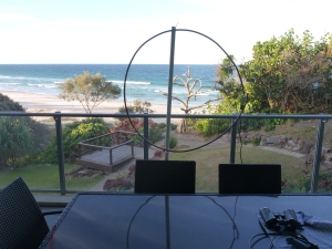
Beachfront loopy style © 2014 FM DXing

The FM loop antenna may offer satisfactory reception whilst travelling on vacation (above) or on a field trip. Under these situations, a small FM yagi antenna may be considered too obtrusive or unwieldy. The loop offers a compromise. Surely, that is an incentive to get out the city into some fresh air!

Example #1: Beachfront resort

On the small balcony of a 2nd floor beachside apartment, permanent tropospheric scatter reception from 80 kW public services northwest was possible at 354 km / 220 mi with this loop antenna.

Beachfront loopy style © 2014 FM DXing

Beachfront loopy style © 2014 FM DXing

‘Dead of winter’ conditions prevailed, which were typical for mid July. However, these signals were comfortably audible (e.g. strong enough to trigger Yamaha’s CSL) over five consecutive nights.

Beachfront loopy style (MTV Unplugged!) © 2014 FM DXing

Beachfront loopy style (MTV Unplugged!) © 2014 FM DXing

Fading occurred only very briefly. The maximum elevation on the balcony was 22 m / 72 ft ASL.

Beachfront listening © 2014 FM DXing

Beachfront listening © 2014 FM DXing

A component FM tuner was used at this apartment with the loop.

Beachfront listening, local reception © 2014 FM DXing

Beachfront listening, local reception © 2014 FM DXing

Example #2: D’aguilar Range portable field trip

At a secluded spot on the D’aguilar Range, the loop was mounted in the carpark on a three metre PVC mast. The circular antenna can be accommodated in a sedan by collapsing the rear seat.

Mountains loopy style © 2014 FM DXing

Mountains loopy style © 2014 FM DXing

Upon arrival on-site, the loop took less than five minutes to erect by moonlight (if one is lucky!) or torchlight. OK, so she ‘looks a bit worse for wear’ on this occasion, but nonetheless performs!

Mountains loopy style © 2014 FM DXing

Mountains loopy style © 2014 FM DXing

At this location, the lowest figures from the altimeter (taken between 10-10:30 pm) indicated an elevation of 468 m / 1,535 ft ASL with a warm ambient temperature of 10.8 degrees C / 51 F.

Mt Samson © 2013 Berknot

Mt Samson © 2013 Berknot

The spot was located between the SOTA (Summits On The Air) mountains of Sim Jue and Samson.

Mt Samson © 2013 Berknot

Mt Samson © 2013 Berknot

The date of the trip was early August at 10:30 pm. Despite a very congested FM dial, the following services listed below were heard in flat conditions with a tropospheric index of nil. These stations are never heard permanently at home during winter, apart from some of the northern reception. An obstructed southern path (which includes the McPherson range topping 1,359 m /4,459 ft ASL) may be the likely explanation.

Rebel logo © 2014 Rebel Radio Network

Hitz FM logo © 2014 Bundaberg Broadcasters

North

  • 3 kW commercial services at 274 km / 170 mi
  • 1 kW commercial service at 217 km / 135 mi

4DDD logo © 2014 Dalby Broadcasting

West

  • 2 kW community service at 145 km / 90 mi

Now FM logo © 2014 Moree Broadcasting

South West

  • 100 kW commercial service at 416 km / 258 mi

Ten FM logo © 2014 Ten FM Community Radio

Life logo © 2014 Life FM Community Radio

South

  • 15 kW commercial services at 331 km / 206 mi
  • 1 kW community service at 272 km / 169 mi
  • 100 watt commercial services at 169 km / 105 mi
  • 50 watt public translator at 163 km / 101 mi
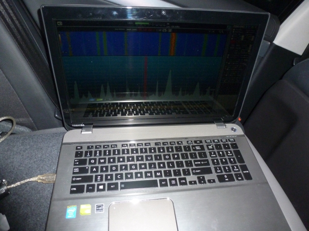
Recording at mountains in car, loopy style! © 2014 FM DXing

Recording at mountains in car, loopy style! © 2014 FM DXing

A brief check with the car radio indicated that the majority of these stations were not audible with the car radio antennae. This suggests that the loop was performing as it should. In fact, one of the 5 kW commercial services located 77 km / 48 mi south was audible as an image on the receiver. Simply, there were no obstructions in the site’s path.

Live in the city? A field trip can be rewarding fun with any tuner or antenna!

JamesMP has some taken some interesting photos of the aforementioned Dundas mountainous region. Previously, reception at this region has been discussed in this series.

Example #3: Beachfront apartments

These photographs illustrate the ease of assembling the FM loop antenna at two contrasting beachside apartment complexes, located just 900 m / 0.6 mi apart.

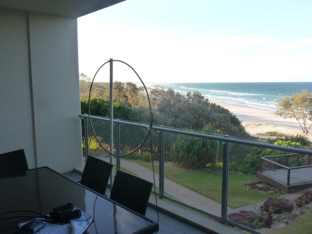
Beachfront loopy style at a favourable location © 2014 FM DXing

Beachfront loopy style at a favourable location © 2014 FM DXing

On the balcony of a 14nd floor beachside apartment, permanent tropospheric scatter reception from 80 kW public services northwest was possible at 578 km / 359 mi with this loop antenna in mid October. Signals were audible every evening during the stay. The maximum elevation on the balcony was estimated to be 60 m / 197 ft ASL.

Beachfront loopy style in tough conditions © 2014 FM DXing

Beachfront loopy style in a ‘shocker’ of a location © 2014 FM DXing

Contrast the observations directly above to those in a complex above a popular entertainment precinct! On this particular 15nd floor balcony, all modes of long distance FM reception were affected by enormous levels of electrical interference. In addition, dozens of high rise apartment towers in close proximity attenuated signals. These observations may reflect a worst-case scenario.

Despite this apartment building being a ‘shocker’ of a location, FM signals received with the loop were more distant than results using the vertical telescopic antenna on the Silabs’ portable receiver. (The portable receiver exhibited images across the FM band. This symptom ‘masked’ weak signals, of course).

At this location, the antenna could not be left outside overnight or positioned at the top of the PVC mast, both of which are normally undertaken. Why not? The antenna was readily visible from neighbouring balconies and possibly from the busy tourist strip below.

The maximum distance at this location was 402 km / 250 mi from 100 kW public services. This reception was only possible during enhanced conditions; those stations were not permanently receivable each night. The antenna was moved inside the apartment after 9 pm nightly which may have limited opportunities for more distant signals.

Distances & azimuths of FM broadcasts are calculated with FM Scan. Station logos are solely provided for the purposes of research & education under the Fair Use provisions of the Copyright Act in this jurisdiction. This article will be continuously updated, it is a work in progress.

It’s all Mee

On the evening of April the 23rd, a spontaneous decision was made to travel to Mount Mee. This mountain is also part of the D’Aguilar range. Access was via Dayboro (below).

Tourist drive sign, Dayboro

Once at the destination (below), altitude and temperature measurements were taken.

Tourist drive sign, Ocean View

The photo (below) illustrates conditions. The weather was fine with a temperature of 27.8 degrees celsius. The altitude was approximately 580 metres above sea level. There was no fog present (one indicator of potential tropospheric ducting).

Altitude, Mount Mee

The altitude is no match for the mountains of Glorious and Nebo on the same range, but the location is probably easier to navigate. Whilst permanent FM reception suffers at Mount Mee, there are far fewer residential streets. That means more remote parking spots are available to choose from. There is also less risk of getting the car bogged in mud.

This video shows broadcasts from Rocky & Bundy, including:

  • 105.5 News Radio – Rocky (QLD) – 80 kW – 435 km
  • 103.1 Radio National – Rocky (QLD) – 80 kW – 435 km
  • 93.9 4RUM Hitz FM – Bundy (QLD) – 3 kW – 252 km

Prefer a longer recording of News Radio?

This video shows broadcasts from the Kingaroy CBD and an unknown Christian station. If readers have any clues regarding 100.5 MHz, please don’t be shy! None of the stations filmed have been heard in the city:

  • 93.1 Radio TAB – Kingaroy (QLD) – 25 watts – 108 km
  • 96.3 K FM – Kingaroy (QLD) – 50 watts – 108 km
  • 100.5 Was ist diese Station?

K FM logo © 2012 Radio K FM

With the car facing north, co-channel interference from Lismore was alleviated. As a result, RDS (below) was possible from this 5 kilowatt station, 101 kilometres away.

Zinc 96.1 FM RDS

RDS (below) was taken from this 200 watt translator, 79 kilometres north.

Hot 97.9 FM translator RDS

The aforementioned Mount Mee highlights were made with a ‘marginal’ Hepburn tropospheric index of 1.4.

As good as it gets

Last year, memorable mountain top reception was heard at the same spot. On those occasions, moderate tropo ducting prevailed; so weather conditions were optimal for some planned mobile FM madness.

1 May

98.3 2NOW Now FM Mt Dowe – Narrabri – 100 kW – 435 km

10 May

107.9 Hot FM Mt Archer (pictured below) – Rocky – 10 kW – 471 km

Mt Archer, Rocky © 2011 Sophie Benjamin

The following bloggers have photographed D’Aguilar NP. Their travels and observations are definitely worth reading:

Mt Mee Wedding
Relocation to Mt Mee
Sunday drive to Mt Glorious
Day trip to Mt Nebo
Camping at Archer Creek

A previous trip to Dayboro can be found here. Coming up: the final entry from Mt Glorious.

Station logos are solely provided for the purposes of research & education under the Fair Use provisions of the Copyright Act in this jurisdiction.

A glorious vista part two

Mount Glorious is an ‘urban mountain’ that is a well known destination for hiking, bird watching and televison/radio projects, situated in the D’Aguilar National Park. Briefly, FM radio reception was observed in a street with an altitude of 767 metres above sea level. This may be indicative of permanent reception possible.

Steps, Mt Glorious © 2006 Sherwin Huang

By using specialized car receivers & antennas, high altitude ‘mountain topping’ may offer better long distance FM reception compared to multi-element, rooftop yagi antennas in built-up areas. For the uninitiated, beware that there is a catch! Mountains rarely provide unobstructed paths to all towns. No matter how high the receiving location is, nearby mountains in this region tend to kill any opportunity of reception from one or more particular directions, even if the surrounding mountains have lower altitude. At Mount Glorious (for example) serious impediments affect line of sight to the north.

The on-line path profiler Hey What’s That suggested the mountains of O’Reilly (503 m), Lawson (473 m) and Samson (689 m) may obstruct reception towards the north. This proved accurate with no Bundaberg FM stations receivable under baseline conditions. Towards the north-east was another impediment, Mount Tenison Woods (757 m).

Sunrise, Mt Coot-tha © 2009 Angus Veitch

The 100 kilo Watt stations on Mount Coot-tha (above) are sited 22 kilometres east of Mount Glorious. Images of Nova & ABC Classic FM from there appeared on 102.3 & 103.1 MHz, respectively. These ghost signals were noticeable only when the automotive antenna was orientated towards the east.

The average portable may ‘shit its pants’ here in Brisbane Forest Park, which is why using a car radio is likely a better choice! Back in the 2000s, this sensitive portable (which is still functional) was taken to a vegie BBQ at Jolly’s Lookout, Mount Nebo. Regarding FM reception, no wonder there was disappointment!

Sony WM-FX77 © 2010 amormusicyjh (blogger)

Highlights from a predominantly unobstructed SSW-S-SSE coastal path (based on Hey What’s That terrain analysis) included:

91.3 2ABCRR ABC Central West Bonalbo (NSW) – 50 watt translator – 160km
(never heard in the city)

98.7 2ABCFM Classic FM Taree (NSW) – 100kW – 486km &

99.1 2NWR ABC New England Mt Dowe, Narrabri (NSW) – 200kW – 415km

*102.5 The Breeze Mt Mackenzie, Tenterfield (NSW) – 4kW – 211km (corrected)
(never heard in the city)

This video shows broadcasts on 98.7 & 99.1 MHz from Taree & Narrabri, respectively. Note the ‘spew’ audible on 102.3 MHz.

RDS was receivable on 88.9 MHz from the Breeze translator, 88 km south-south-east. 92.1 MHz also has RDS.
(88.9 MHz never decoded in the city)

RDS PS

RDS RT, The Breeze FM 88.9

On 99.1 MHz, a Toowoomba narrowcast operation was heard mixing with Narrabri. The music programming was ‘old time stuff’. According to the website, this is Kids FM. Without hearing an ID this is a guess but it fits, being 85 km west-south-west.

Kids FM © 2013 Southern Cross Austereo

These Mount Glorious highlights were based on half an hour of listening during the early evening on 18 March (recording denoted with an asterisk) & 15 April. Fine weather prevailed. The Hepburn tropospheric index was marginal / 1.4.

These two recent trips suggest it is likely that tropospheric scatter varies noticeably at this altitude on a daily basis. Permanent residents would be better qualified to judge whether this observation is accurate.

Thank you to the companions on the trips for assistance with compass direction-finding, photography, three point turns in bogged mud, car washing & night navigation. Not quite as bad as this!

Bogged car © 2006 mundoo

This is a three part entry. The rationale was to split this into parts rather than bombard ‘time-poor’ readers with too much information at once. Next week, the final section will be published with four more clips from Mt Glorious & Mt Mee. There will also be some photos of the beautiful scenery… so ideally it’s not too dull!

Southern Cross Austereo is owner of the copyright in the logo for Kids FM. Station logos are solely provided for the purposes of research & education under the Fair Use provisions of the Copyright Act in this jurisdiction.

The copyright holders of photography included on this blog have licensed their works under the Creative Commons for non-commercial use (such as this not-for-profit blog) with attribution. To view more of their work, type the photographer’s name into Flickr.

Altitudes specified are approximate, based on GPS mapping. Distances are from FMscan.